


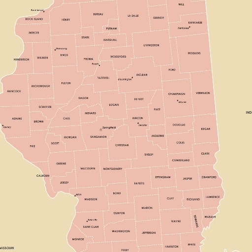
Add clarity, style, and timeless character to your space with this Printable Illinois Map, thoughtfully designed in a soft, neutral palette that complements nearly any interior aesthetic. Whether you’re decorating a cozy study, curating a gallery wall, or enhancing a learning environment, this modern digital map blends clean design with practical detail. It showcases Illinois with counties, major cities, and the bordering states in a crisp, portrait-oriented layout – making it both beautiful and informative.
Available as a high-resolution 600DPI digital download, this Illinois map print transforms effortlessly into a statement piece for modern décor, minimalist interiors, boho wall décor themes, or neutral wall art collections. As a versatile design, it suits homes, offices, libraries, classrooms, studios, or any space where geography meets elevated visual style.
A Modern Minimalist Take on the Illinois Map Print
This artwork was created for anyone who appreciates a refined approach to map design. Instead of bold colors or heavy borders, the map uses subtle tonal variations and thoughtful spacing to highlight each county while maintaining an elegant and uncluttered appearance. The Illinois map poster includes clearly set county outlines, major city labels, and a balanced arrangement that feels calm and visually engaging.
The neutral palette enhances the map’s adaptability. It stands out beautifully when printed at large sizes for wall display, yet remains easy to read at smaller scales for educational or reference use. From contemporary décor to rustic or Scandinavian themes, the artwork slips naturally into many styles without overwhelming the room.
High-Resolution for Professional-Quality Printing
Every file in this set is rendered at 600DPI, which means the final print will appear sharp and detailed – even when scaled to the largest recommended sizes. Typography remains smooth, county borders stay precise, and the overall composition maintains its clean, polished finish.
After purchase, you’ll receive a zipped folder containing five high-quality JPEG files, each formatted for a different aspect ratio to match a wide range of frames and print options. These include:
- 3:4 ratio – Maximum size: 18×24 inches
- 4:5 ratio – Maximum size: 24×30 inches
- 2:3 ratio – Maximum size: 24×36 inches
- 11:14 ratio – Maximum size: 22×28 inches
- A-series ISO ratio – Maximum size: A1
Because all images are high-resolution, they can also be printed at smaller sizes within the same ratios – such as A2, A3, A4, or A5 – without losing clarity. This flexibility allows users to frame the artwork for large feature walls or print compact versions for binders, classrooms, or bulletins.
Why Choose This Printable Illinois Map?
This map combines artistry with accuracy. It’s ideal for anyone looking for a thoughtfully designed Illinois wall art piece that also serves as a functional geographic resource. Whether you’re an educator teaching state geography, a traveler highlighting your favorite locations, or a homeowner styling a modern room, this map offers a polished solution.
Key features include:
- Portrait orientation for a clean, vertical presentation
- Minimalist styling that prioritizes elegance and readability
- Detailed county layout for accurate reference
- Major city labels placed with balanced spacing
- Neutral tones suitable for modern, boho, and minimalist décor
- Instant digital delivery, allowing users to print exactly how and where they prefer
Because it’s a digital product, you can choose the printing method that best matches your vision – professional print shop, home printer, canvas printing service, or even large-format poster output.
Perfect for Home Styling, Education, and Personalized Décor
This Illinois map print invites endless creative uses. Hang it above a desk for a touch of inspiration, frame it for a living room gallery wall, or display it in a classroom to support geography lessons. It works beautifully as:
- Neutral wall décor in modern or minimalist homes
- Boho wall décor when paired with natural textures or warm tones
- Office artwork, adding quiet sophistication to professional spaces
- Educational reference, offering a clear breakdown of counties and nearby states
- Giftable artwork, especially for students, teachers, travelers, or Illinois natives
Because the design is understated, it pairs well with photographs, travel pins, typography prints, or other neutral artwork, making it easy to integrate into curated collages.
Designed for Ease, Flexibility, and Long-Term Use
Users can print this map as many times as needed for personal or educational use. Frames of different proportions are easy to accommodate thanks to the included aspect ratios, and you’ll never have to worry about pixelation or blurriness due to the ultra-high 600DPI resolution.
Whether you mount it behind glass, print on heavyweight matte paper, or choose a textured canvas, the artwork maintains its refined look. The minimalist approach ensures it remains timeless, even as interior styles evolve.
A Premium Printable Map
This printable Illinois map is more than a reference – it’s an art piece designed with care. With its subtle composition, detailed county layout, and modern aesthetic, it becomes a striking yet peaceful addition to any environment. From decorative displays to practical geographic insight, this map bridges both worlds effortlessly.
Elevate your space with a beautifully crafted representation of Illinois – available instantly, ready to print, and designed to complement a wide range of décor styles.
Reviews
There are no reviews yet.